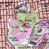
SF-89C Mount SutroN 37.75822°, W 122.45721°, elevation 892 feet |
|
SF-89C Mount SutroN 37.75822°, W 122.45721°, elevation 892 feet |
|
On Mount Sutro, in the heavily wooded area north-west of the TV tower.
No visible remnants on the mountain top, everything is covered over with
eucalyptus chips.
It's possible there are still radar pads underneath the chips.
One building remains lower down, where the gated road starts.
Access: from Parnassus St. at the UC Medical Center, up
Medical Center Way to Johnstone Drive, and then up that to the end
at Behr Road.
Or take Clarendon to the other end of Johnstone Drive.


